
Public Participation Process:
Comment on the Draft Concept Design
A stakeholder engagement process to obtain input on the draft concept design commences on Thursday, 28 May 2026 and will end on Monday, 6 July 2026.
Your feedback will help refine the draft concept to better address community priorities, technical feasibility, and environmental considerations.
To share your input, please provide comments using the form below or any of the contact methods listed, by 6 July 2026.
Comment on the Land Disposal
Statutory public participation for the proposed disposal of land in terms of the Municipal Asset Transfer Regulations (MATR) will take place in parallel from Thursday, 28 May 2026 to Monday, 6 July 2026.
Please note that this is a separate but parallel process to the stakeholder engagement on the draft development concept. To comment via email on the proposed land disposal in the MATR process, please use the button below.
PROJECT BACKGROUND
The City of Cape Town's Property Development Department is undertaking a structured process to assess the long-term future of portions of City-owned land at the King David Mowbray Golf Club precinct. In 2015, the City of Cape Town’s Spatial Planning and Urban Design Department conducted an initial investigation which found that the site holds meaningful potential for contributing to broader municipal objectives and may be appropriate for consideration as a mixed-use infill development.
A further pre-feasibility assessment was undertaken in 2022 to evaluate whether development on the site would be viable from a planning, environmental, engineering and economic perspective. Given its strategic location, accessibility and scale, the precinct holds metropolitan significance and presents opportunities for creating a more inclusive, integrated and multi-functional urban environment. These opportunities are currently being explored through detailed specialist studies and impact assessments.
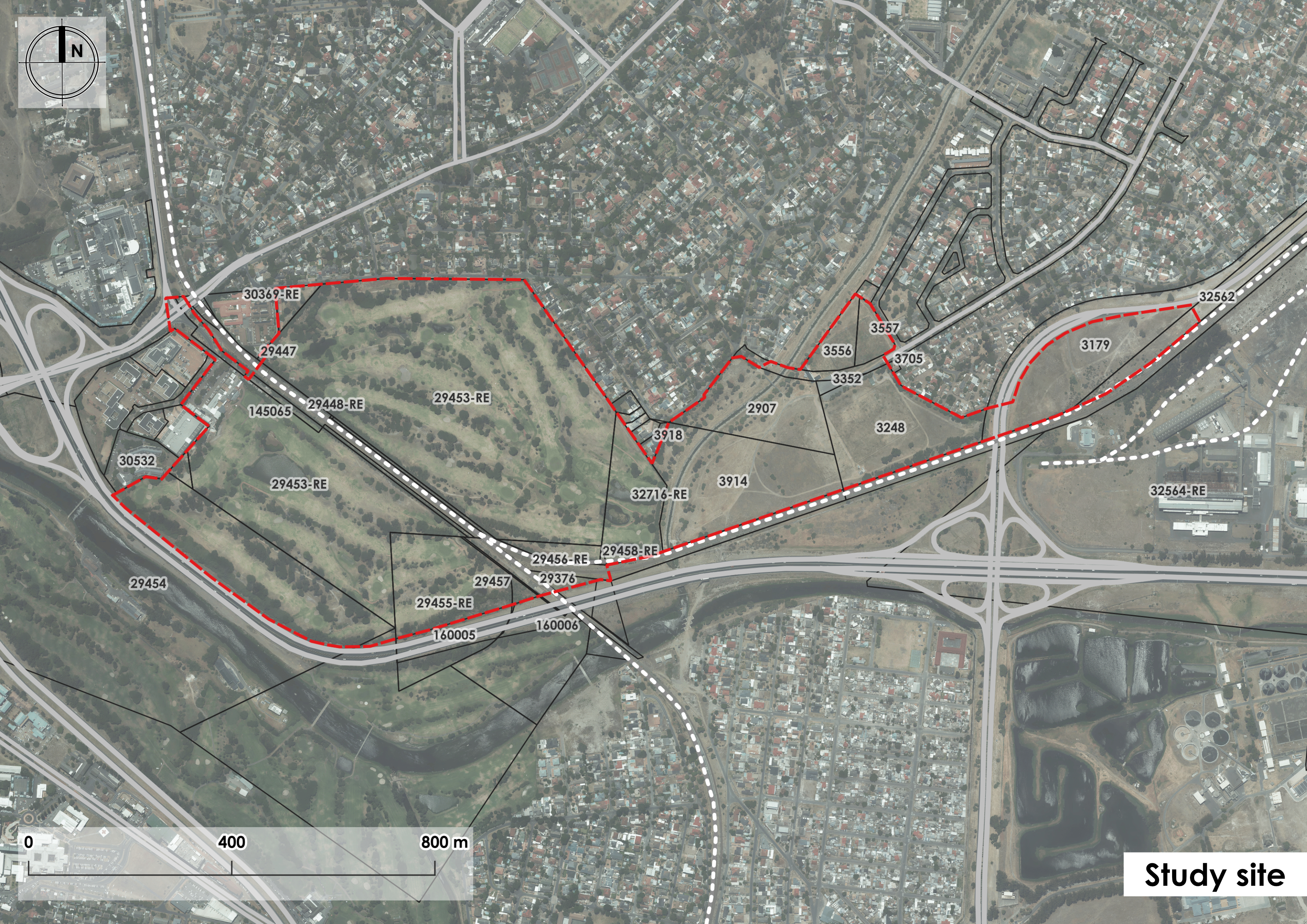
The precinct under consideration is approximately 74ha in extent and comprises the King David Mowbray Golf Course, the Clyde Pinelands Association Football Club and sports fields, as well as a portion of undeveloped land to the east of the site. The site lies approximately 9km from Cape Town Central Business District and 12km from the Cape Town International Airport. The site is situated north of the Rondebosch Golf Course across the Black River and is bounded by Settlers Way (N2) to the south, Links Drive to the north, and Raapenberg Road to the west.
The first voluntary public engagement introduced the project and outlined the City's early vision and intentions to explore a range of possibilities for the future precinct. At that stage, the City explained that a series of specialist studies, technical investigations and baseline assessments would be required to inform any potential concept.
Since February 2025, the multidisciplinary project team has been undertaking these baseline investigations to build a clearer understanding of the site's environmental, heritage, engineering, transport and social context. The purpose of this work is to ensure that any emerging concept is grounded in accurate, evidence-based information.
PROJECT TIMELINE
November 2024 - January 2025
Pre-Registration Stakeholder Engagement
Identify potential interested and affected parties through a registration process.
November 2024 - January 2025
February 2025 - April 2026
Vision and Objectives Stakeholder Engagement
Determine the design informants, vision and project objectives with a public open meeting.
May 2026 - July 2026
Draft Concept Development Stakeholder Engagement
Share the draft development concept with the public and refine based on public comment.
May 2026 - July 2026
May 2026 - July 2026
Statutory Public Participation for the Proposed Disposal
Public participation in terms of the Municipal Asset Transfer Regulations (run in parallel with the draft concept development stakeholder engagement).
August 2026 - February 2027
Statutory Public Participation
Compliance with legislation and regulations through open houses, report publication and commenting periods.
August 2026 - February 2027
DRAFT DEVELOPMENT CONCEPT
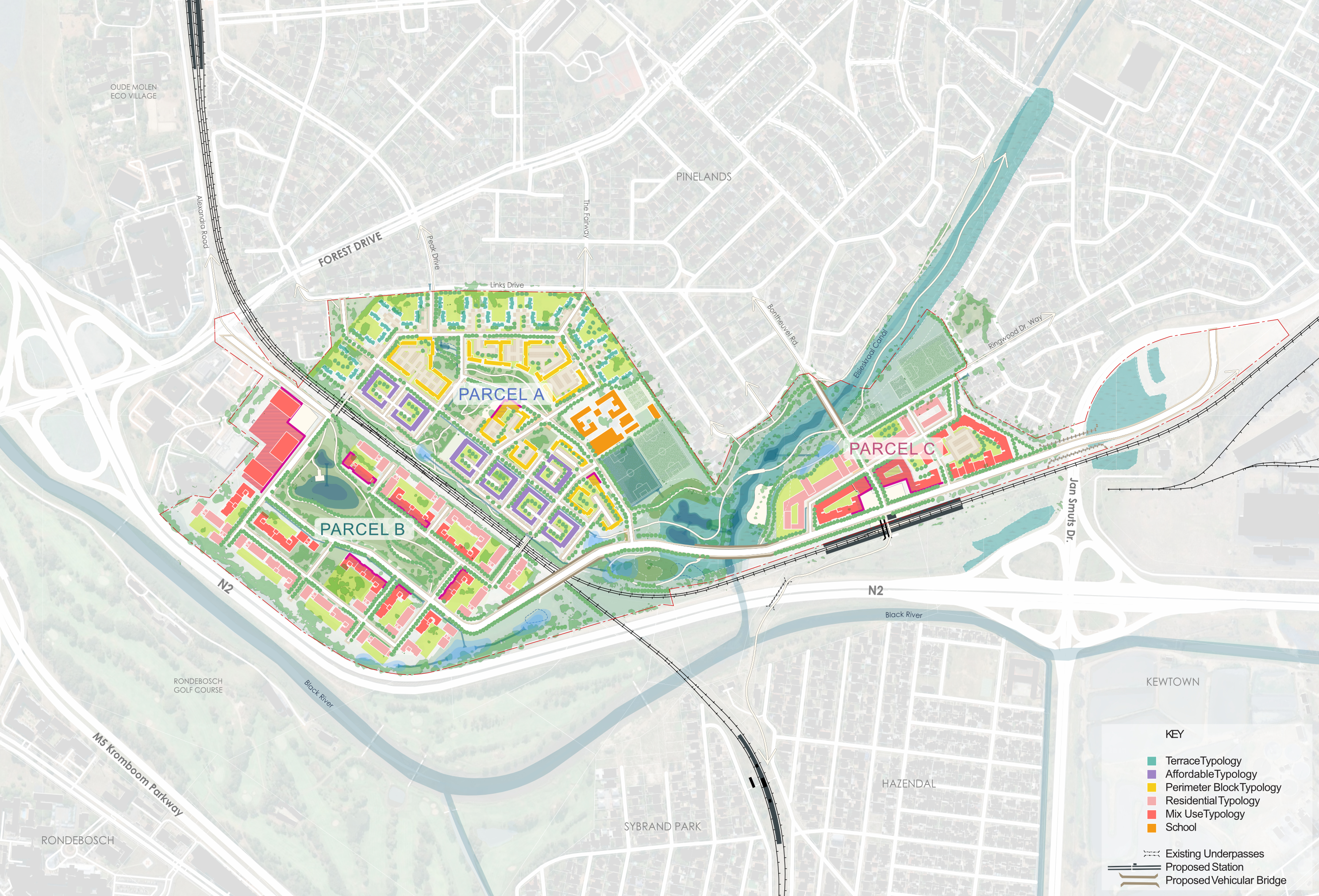
The draft development concept includes residential development with a 30% affordable housing component, commercial, retail, and light industrial uses, a new school, and community and sports facilities. A varied built form is proposed across the site, with smaller land parcels, a finer grain and lower-density buildings positioned adjacent to the existing residential fabric. Progressively larger, higher-density buildings are introduced closer to the Black River and the N2 and M5 Freeways. The flood lines, ponds and wetlands have been taken into account during this draft design phase, where specific ponds will be retained for recreational and stormwater uses, and no hard infrastructure will be constructed within the 1:100-year flood line.
The proposed concept retains trees as a key structuring element and feature of future public spaces wherever possible.
The public realm will be seen as an opportunity to provide value through well-considered design and placemaking. This is done to ensure an attractive, comfortable and functional development. There will be considerations such as movement around the site, public space and interface, spatial quality and the relationship between the site and its context. The success of the public and semi-public realms relies on the interface with the developments around it. This will be considered within the development framework and is to be replicated within each development plot as they interact with either the public or semi-public realm within.
For additional information on the draft development concept, please download the Information Document seen below under the Documenting the process section.
Public Open House
All interested and affected parties are invited to attend an open house where information on the proposed concept will be on display and the project team will be available for queries and discussion.
The posters will be avaliable for download on this website on Monday, 22 June 2026.
Saturday, 20 June 2026
King David Mowbray Golf Club
REGISTRATION AND COMMENT FORM
Please use the form below to register as an Interested and Affected Party and comment on the draft development concept.
The commenting period closes on Monday, 6 July 2026.
FREQUENTLY ASKED QUESTIONS
Comments and queries received during previous consultation processes have been considered by the professional team and the City of Cape Town, and incorporated into the draft concept design. A summary of comments received and the way they have been addressed and considered is provided below.
Comment summary
A number of commenters raised questions about the City's motivations and the basis on which the site was identified and the project structured.
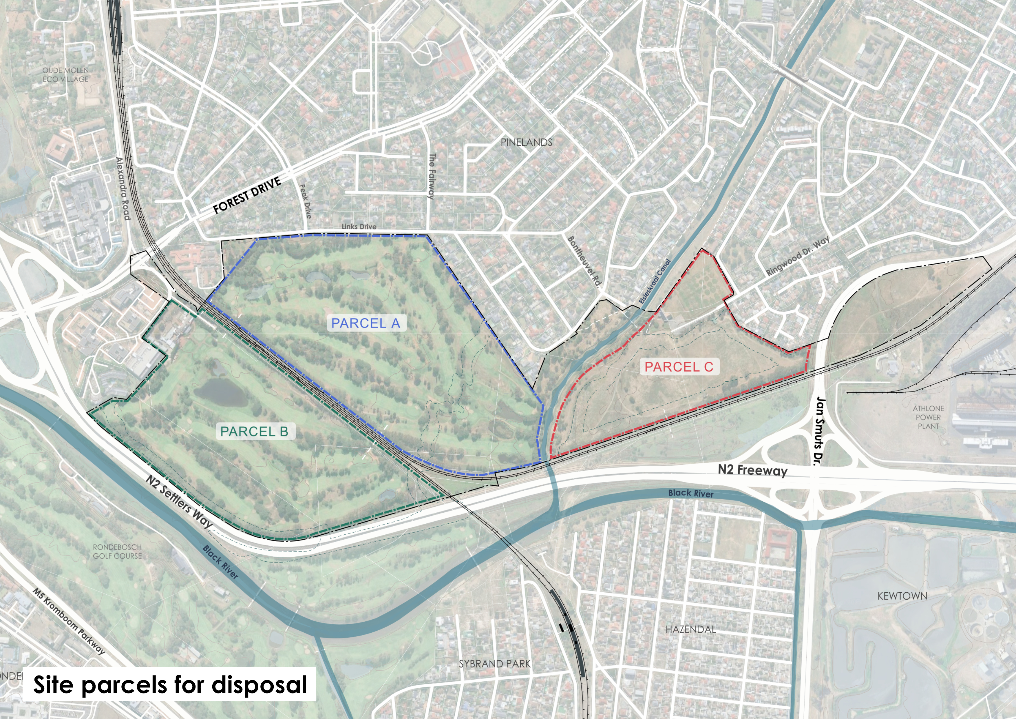
There were also questions raised about the Council resolution authorising the Public Participation Process (PPP) and whether it covered all three portions (A, B, and C) of the development area. Commenters argued that the Council's authorisation of the PPP covered only Portions A and C, not Portion B of the golf course, and that the inclusion of Portion B in the process was not legal. The letter demanded withdrawal of the current PPP and initiation of a new, properly authorised process. Commenters also called for a more transparent and legally binding framework, noting concerns about the adequacy of affordability commitments and the risk of private developer capture.
Response
The City of Cape Town’s Property Development Department is undertaking a structured process to assess the long-term future of portions of City owned land at the King David Mowbray Golf Club (KDMGC) precinct. In 2015, the City of Cape Town’s Spatial Planning and Urban Design Department conducted an initial investigation which found that the site holds meaningful potential for contributing to broader municipal objectives and may be appropriate for consideration as a mixed-use infill development. A further pre-feasibility assessment was undertaken in 2022 to evaluate whether development on the site would be viable from a planning, environmental, engineering and economic perspective. Since February 2025, the multidisciplinary project team has been undertaking these baseline investigations to build a clearer understanding of the site’s environmental, heritage, engineering, transport and social context.
The City of Cape Town aims to provide mixed-use development on the site, inclusive of residential, with affordable housing, retail, commercial and light industry uses. The City plans to offer the development rights to the market through a disposal process, and will apply for the relevant land-use approvals to enable mixed-use development on the site.
Given the strategic location and scale of the King David Mowbray Golf Course precinct, any future planning and development proposals will need to follow a Package of Plans approach, as provided for in Item 136 of the City’s Development Management Scheme (DMS). When approving a Package of Plans, the City shall determine the “basket of development rights” attributed to each of the three development parcels. Future development must then adhere to these development limits. The Package of Plans and Basket of Development Rights define what a developer can and cannot do, providing certainty upfront while preserving the City's ability to enforce design quality and land use mix. The developer is generally required to fund and upgrade or construct the internal bulk infrastructure including transport, sewer, water and electrical infrastructure.
The City of Cape Town is undertaking a separate statutory process in terms of the Municipal Asset Transfer Regulations for the disposal of land. Parcels A and C were approved by Council for release however, no statutory public participation process had taken place for parcels A and C. All public commenting periods were voluntary engagements. Recent Council decision formally approves Parcels A, B and C for statutory public participation in terms of the MATR. This commenting period will run from 27 May to 6 July 2026. Comments regarding this statutory process can be sent to Development.Mowbray@capetown.gov.za